

Liverpool Ghost Streets 5: The Floating City
Labels: City Living / Feature / architecture / Featured / liverpool ghost streets / liverpool's ghost streets
A generation ago, our Council leaders had a bright idea. They wanted us to never make contact with the ground again. But we weren’t promised jetpacks, just dimly lit corridors in the sky.
Take a closer look at Moorfields station. It has the dubious distinction of being the world’s only underground railway station where passengers from the street have to ascend to the first floor concourse before they can descend beneath the surface to catch their train.
The curious design is a remnant of a plan to stop us ever reaching the pavements at all. If our town planners had their way, our feet wouldn’t be touching the ground.
Back in the late 60s, the City Council had a vision to create aerial walkways above the city streets - from Mount Pleasant to the waterfront. Like some huge Go Ape! fun park, a lattice of levitating gangways and gantries would keep us from ever having to deal with the traffic clogged streets below.
Back then, cars really were king, and we had to make way. Rise above. Now, of course, it’s practically impossible to drive around town. Back then, they wanted to make it difficult for us to walk.
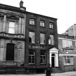
So how far did the plan get? Well, surprisingly, quite a lot of the bridges, balconies and infrastructure was completed. Remember the bridge across to the ‘gyratory’ by the Royal Court - pic above - that was one. Seen the amputated walkway hovering mid-air next to the new Travelodge, on The Strand? That’s another.
The overhanging protrusion above No1 Old Hall Street isn’t just a fancy sun shade - it, too, was destined to be a walkway. Follow your eyeline across the road, and it meets a hole in the wall of the opposite building, above the Old Hall Street entrance to Moorfields. Never spotted that before, did you?
Much more, of course, has disappeared - the last bridge, across the Strand to Beetham Plaza, was demolished in 2006. You can still see the remains of where it joined the Plaza, behind Etsu.
But it’s not just walkways. Many of the city’s buildings, too, were engineered to be accessed from the first floor, not street level. That’s why St John’s Precinct has that external balcony, and why you’ll see office buildings with external, first floor walkways: in Cheapside, and Hatton Garden (pic below - spot the outside walkway) to this day.
Many of the walkways started life in our huge, inner city housing schemes - like St Andrew’s Gardens, St Oswald’s House and Gerrard Gardens, allowing residents to pop into Lewis’s and back without putting a foot on the ground.
In those brave new world post war days, Liverpool was considered to be a bit of a pioneer when it came to cutting edge civic planning (the University’s Department of Civic Design is Britain’s oldest, opened in 1909).
We were, after all, a planned town from the beginning. Those seven streets you may have heard of? They were deliberately laid down in a grid pattern - which, more or less, paved the way for the modern street plans of every city since.
So, with hindsight, it seems odd that we were so keen to separate the city from its streets. But such was the fervour for first floor living, notices like this (about the development of the 051 complex) were a regular occurence on the lampposts of the city in the late 60s/early 70s:
LIVERPOOL CORPORATION ACT
Provision of a City Walkway 1969
Notice is hereby given that the City Council has received an application for planning permission to erect a multi-storey building comprising an Entertainments Complex consisting of a Hofbrauhaus, Restaurant, three Cinemas and a Discotheque with two floors of separate offices over, on a site west of the Mount Pleasant multi-storey car park between Brownlow Hill and Mount Pleasant. Included in the proposal is provision for a city walkway. This walkway forms part of a planned system of elevated walkways in the City Centre and will connect with a walkway incorporated in the Mount Pleasant car park. Together these walkways will form part of a system which will start on Brownlow Hill, cross Mount Pleasant and Renshaw Street and link with the west pavement of Renshaw Street. Any persons who wish to make representations about the proposals for the City walkway should make them to me in writing before the 1st February 1973.
“Liverpool’s devotion to rebuilding is nothing new,” says Emeritus Professor Simon Pepper, of Liverpool University’s School of Architecture. “For a long time, the council was Britain’s number one when it came to pulling things down. It kept on long after other cities more realistically switched to refurbishing their valued older buildings.”
“We’ve seen whole phases of design ideas, one wave after another. The elevated pedestrian pavement network of the late 1960s was a complete disaster. Students of major postwar civic blunders still come to savour a remnant of this particularly ill-conceived planner’s paradigm,” he says.
It was, says Professor Pepper, a direct result of our addiction to petrol that lead to the scheme: “Without doubt the biggest impact on our cities and towns was the explosive growth in motorised road vehicles since 1945. As a result, civic engineers were given unprecedented authority to rip up established communities and commercial areas, driving through new roads to resolve the traffic problem.”
The streets in the sky never really did take off. But, curiously, its legacy remains. When it was first proposed, the planners talked about how they’d taken as their model Chester’s first floor ‘rows’ - a 12th century civic construction that still works today.
Odd then that, in Liverpool ONE, those first floor walkways have returned and - by all accounts - arrived to save the city’s fortunes.
Maybe our Council leaders were just too ahead of their time?